| 2005 |

|
YEAR BOOK |
Queen's University Belfast
|
Geographical information systems and spatial analysis: applications in the physical and social sciences
|
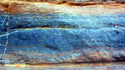
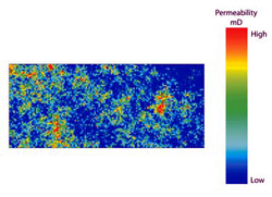
Characterising oil bearing reservoirs is central to efficient extraction of oil. A body of approaches called geostatistics has been developed which can be applied to the analysis of reservoirs. In work at QUB, rock outcrops which are analogous to environments in which oil has been extracted have been studied to provide information about how the properties of such environments vary spatially. Such information may be of extensive use in petroleum geoscience. A particular concern has been generating maps of permeability (that is, the degree to which gas or fluid can pass through the rock) of these rock outcrops. Firstly, a device called a probe permeameter is used to measure the permeability of the rock at different locations. These point data are used as the basis for permeability maps. The values between the points are interpolated ('filled in') using a method called kriging. These permeability maps can be used to help assess how the rock properties vary from place to place. It is possible to construct, through a simulation procedure, multiple alternative versions of these maps and these outputs can be combined to allow assessment of uncertainty in the outputs. This work is being expanded to cover a range of different environments with the objective of compiling an index of spatial variation given different conditions.
These diverse areas of research illustrate the wide range of contexts within which GIS can be applied for helping to solve problems in the physical and social sciences.
|
|
Contact: Dr Chris Lloyd, School of Geography,
Queen's University, Belfast, BT7 1NN.
E-mail: [email protected]