| 2005 |

|
YEAR BOOK |
Institute of Technology,Tralee
|
Organic waste management system at IT Tralee
|
Stage 1
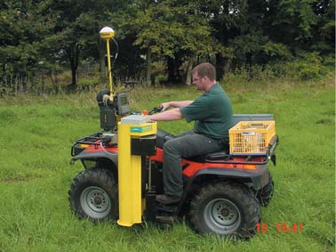
Fields are mapped and scanned using a non invasive soil electrical conductivity unit. This provides a colour coded map of soil's physical properties and management zones. Features such as houses, wells, streams and drains are geo-referenced. Such features may not be easily established on old ordnance survey maps.
Stage 2
A groundwater vulnerability assessment is then carried out on the Geographical Information System where layers of topographic, Karst features and soil hydraulic properties can be overlaid. This results in a directed soil drilling programme where in high groundwater vulnerability areas test holes are drilled to 2 metres using a specially deigned mobile drill on the quad. These test holes are also geo-referenced and soil type and texture are noted.
Stage 3
A nutrient management plan is then used to balance nutrients in the soil and nutrients to be added taking into account climate, soil type, crop needs and concentration levels in the organic material to be added. Detailed heavy metal limit additions are calculated using a specially designed computer programme which ensures compliance to limit additions set out in the European Directive SI 148.
Stage 4
The spreading details are sent via wireless technology to the spreading equipment where the spreaders adjust rates up and down to site specific maps. This stage is currently being implemented on a between field basis rather than a within field basis
Stage 5
All information and records are archived and made available though a web enabled database. This means that this extensive information is made more accessible to the various users, ensures compliance and ensures that expensive scientific information can be used to make informed decisions.
Contact: Richard Hayden or Dr Patrick Carney
School of Science, Institute of Technology, Tralee;
Tel: 066 7145600; Fax: 066 7145651;
E-mail: [email protected]