| 2004 |

|
YEAR BOOK |
National University of Ireland, Galway
|
Mapping the Future the Geographical Information Systems (GIS) Facility at the Environmental Change Institute
|

The facility comprises of a GIS and remote sensing training suite with 10-networked high-spec PCs. Researchers have access to an A4 HP 2200 laser printer, an A3 Colour 5500dn laser printer, and a HP1055cm AO plotter for large-scale hardcopy maps. A second much larger GIS laboratory houses six workstations, two servers each with a capacity of 548GB, an A4 high resolution scanner, and data projector. A high resolution transmission satellite downloads data from the NOAA orbiting satellite six times daily and a receiver housed in the GIS laboratory decodes the information. The data is transmitted using a high-speed ISDN line to the Atmospheric Research Station at Mace Head, Carna, Co. Galway. These significant computer and printing facilities are supported by imaging scanning software, and an AO Summa III graphics tablet for digitizing purposes. GIS and Remote Sensing Software consists of ArcGIS 8.3, ArcView 3.3, ArcIMS 4 and ER Mapper 6.4, as well as MapInfo 7.0 and associated software such as MicroSoft Office.
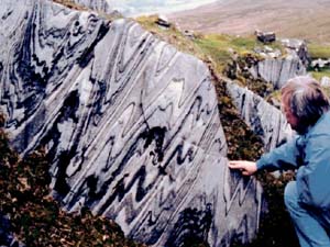
Landscapes in Stone: Digital Perspectives of the Connemara Landscape
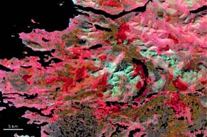
As well as supporting the on-going ECI research programme, which spans five faculties and almost 20 departments, the GIS facility has supported the development of new research proposals and has already begun to build a critical mass of researchers proficient in the use of GIS technology. For example, 'Landscapes in Stone: Digital Perspectives of the Connemara Landscape' is a new geology project led by Dr Martin Feely, Department of Earth and Ocean Sciences, and has attracted funding from the Heritage Council and Galway County Council. The project aims to use satellite imagery and GIS applications to develop a computer generated 3-D digital perspective of the geological and natural landscape of Connemara. It will provide a series of interactive CDs containing digital perspectives of the unique geological heritage of the region, and it will also serve as a means of viewing the topography in 3D. Accompanied by accessible text and relevant narration, this digital mosaic will serve as an excellent means for users e.g. primary and second level education sectors to embark on a highly informative and entertaining virtual tour of the natural landscape of Connemara. The project has been expanded by the award of an IRCSET grant to Ronan Hennessy, whose work will focus on the Twelve Bens region of Connemara. Using Landsat Thematic Mapper and ASTER (Advanced Spaceborne Thermal Emission and Reflection Radiometer) imagery acquired by NASA's Landsat 5 and Terra satellites respectively, and multi-spectral imagery obtained from the French SPOT satellite and Ordnance Survey of Ireland aerial orthophotography, the image sets will be draped over digital elevation models to reveal an almost true representation of the landscape.
Contact: Prof Emer Colleran, Environmental Change Institute, NUI, Galway; or Dr Martina Prendergast, Development Manager;
Tel: 353+91+512263; Fax: 353+91+512515;
E-mail: [email protected] ; or [email protected] ; Web: www.nuigalway.ie/eci