| 2004 |

|
YEAR BOOK |
Ordnance Survey of Northern Ireland
|
Measuring the height of Slieve Donard
|
This figure was shown on the first Ordnance Survey map for the area (1834), and was established by measuring elevation angles above a zero mark defined locally by the level of low water at spring tide. Despite the introduction of a national vertical datum for Ireland in 1837 that redefined zero to Poolbeg lighthouse in Dublin Bay, the published height for Slieve Donard remained unaltered for almost 140 years.
In the 1970s, following the establishment of a new levelling network and the introduction of metrication, the height of Slieve Donard was re-determined from aerial photography as 850.2m above Mean Sea Level (MSL) Belfast.
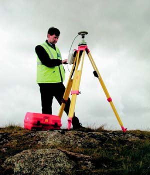
Recent developments in surveying technology, and in particular the Global Positioning System (GPS), now provide an effective method of determining precise 3D positions within a global or European framework (ETRF89). OSNI has previously used this technology to quantify tectonic drift for Ireland, and in May 2004 an OSNI survey team used GPS to precisely measure the height of Slieve Donard.
The fieldwork involved positioning a high quality GPS receiver on the top of the mountain. With the low cloud on the day, traditional survey observations would have been impossible, but GPS is largely unaffected by weather conditions, and observations were recorded over a two-hour period.
For the same period, data were collected by the Active GPS Network, and at a nearby Passive GPS site. The Active network is a series of continuously recording GPS receivers located throughout the UK and Ireland. Raw data from each station is available from the joint OSNI/OSi GPS web site at http://www.osi.ie/gps. The Passive network consists of GPS friendly points with precise coordinates.
All data were brought back to the office for post processing. GPS baselines were carefully calculated and adjusted holding the positions of the Active sites fixed. This provided precise 3D positions for Slieve Donard and the Passive site. Comparison with the previously known position of the Passive site indicated a survey accuracy of better than 2cm.
The GPS heights were easily converted to MSL Belfast using the Ordnance Survey Geoid Model, OSGM02. This final calculation gives a measured height for Slieve Donard of 849.14m above MSL Belfast, and is estimated to be correct to better than 5cm.
At less than 0.3m different to the 1800s measurement, it is a testament to the quality of the work carried out by the original surveyors.
Contact: Ken Stewart, Ordnance Survey of Northern Ireland, Colby House, Stranmillis Court, Belfast BT9 5BJ;
Tel:028 9025 5783; or 048 90255783 (from RoI);