The Irish National Seabed Survey (INSS) undertaken by the Geological Survey of Ireland and the Marine Institute has already achieved 100% sonar imaging swath coverage for mapping of over 600,000 sq km of Ireland's seafloor territories. Initial map products were produced at a scale of 1:250,000, however further processing of the raw sonar multi-beam data is revealing features, hitherto unknown, with potential as cold-water coral habitat. Mini-mounds, not visible on standard INSS charts, were identified following re-processing done by NUIG researchers and re-gridding of the raw multibeam data.
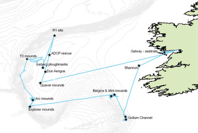 CE0505 Cruise Track
During June '05, a scientific team from the department of Earth and Ocean Sciences in NUI, Galway together with engineers from the Mobile & Marine Robotics Research Centre in the University of Limerick, carried out the first every Irish led Remotely Operated Vehicle (ROV) habitat mapping survey of a number of these areas. The survey (CE 0505) took place aboard the
Celtic Explorer
, the 65m multi-purpose national research vessel. The Bathysaurus ROV was hired in from Argus Ltd, a Norwegian firm based in Bergen.
CE0505 Cruise Track
During June '05, a scientific team from the department of Earth and Ocean Sciences in NUI, Galway together with engineers from the Mobile & Marine Robotics Research Centre in the University of Limerick, carried out the first every Irish led Remotely Operated Vehicle (ROV) habitat mapping survey of a number of these areas. The survey (CE 0505) took place aboard the
Celtic Explorer
, the 65m multi-purpose national research vessel. The Bathysaurus ROV was hired in from Argus Ltd, a Norwegian firm based in Bergen.
A number of days at the beginning of the cruise were spent in Galway Bay with several trips to port during system integration trials of a high resolution acoustic mapping module we acquired as part of a national marine infra-structure programme (the Higher Education Authority Programme for Research in Third Level Institutions). The module consisted of an ROV mountable RESON 8125 sonar multi-beam echo-sounder (soon to be upgraded for the 7125) and high performance position, navigation and motion reference system (IXSEA PHINS fibre-optic gyro based Inertial Navigation System, RDI Doppler Velocity Log and CDL Microbath Digi-quartz precision depth gauge with altimeter). The Marine Robotics group in UL were responsible for integration of this instrument complex on the ROV, integration with topside ship systems and the subsequent operation of the submarine positioning and navigation systems during the near seabed ROV survey operations on the cruise.
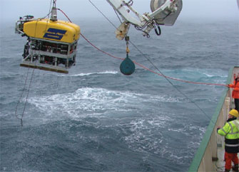 Recovery of Bathysaurus ROV to RV Celtic Explorer
Despite ROV unfriendly weather and swell, the cruise proved a great success. The ROV inertial navigation system, when integrated with the ship-borne DGPS through an ultra-short baseline acoustic positioning system, provided robust and meter scale navigation positioning accuracy at depths to 1,000m. This was particularly useful during the recovery of a valuable Acoustic Doppler Current Profiler, which had been lost on seafloor of the Porcupine Bank for over a year!
Recovery of Bathysaurus ROV to RV Celtic Explorer
Despite ROV unfriendly weather and swell, the cruise proved a great success. The ROV inertial navigation system, when integrated with the ship-borne DGPS through an ultra-short baseline acoustic positioning system, provided robust and meter scale navigation positioning accuracy at depths to 1,000m. This was particularly useful during the recovery of a valuable Acoustic Doppler Current Profiler, which had been lost on seafloor of the Porcupine Bank for over a year!
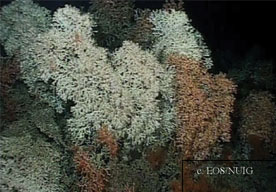 Coral Colonies on Arc Mound
Some of the highlights of the exploratory surveys included the discovery of living coral on a number of small mounds along the southern margin of the Porcupine Bank which we named the Arc and Explorer Mounds, and that an extensive area of shallow (350m deep) mini-mounds, had at one time supported living coral - the mounds in a heavily trawled area, now only contain a covering of coral fragments. Further work is needed to determine whether the coral on these mounds are fossil or recent.
Coral Colonies on Arc Mound
Some of the highlights of the exploratory surveys included the discovery of living coral on a number of small mounds along the southern margin of the Porcupine Bank which we named the Arc and Explorer Mounds, and that an extensive area of shallow (350m deep) mini-mounds, had at one time supported living coral - the mounds in a heavily trawled area, now only contain a covering of coral fragments. Further work is needed to determine whether the coral on these mounds are fossil or recent.
Contact: Dr Anthony Grehan,
(CE 0505 Chief Scientist),
E-mail:
[email protected]
Dr Daniel Toal, Director Mobile & Marine Robotics Research Centre, University of Limerick.
E-mail:
[email protected]
,
Web:
www.ul.ie/~rescisg/C&ISGRobotics.html
Dr Colin Brown, Department of Earth & Ocean Science, NUI, Galway.
E-mail:
[email protected]
Web:
www.nuigalway.ie/eos/
See also or
rhw.staff.ul.ie/omerdic/My%20Papers/ICRODIC2004.PDF
|