| 2006 |

|
YEAR BOOK |
Met �ireann
|
EUMETSAT satellite imagery
|

Better guidance for forecasters
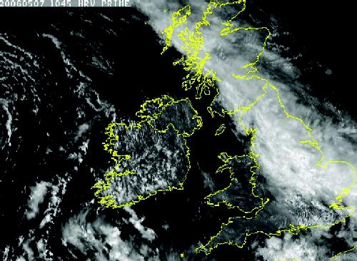
From their geostationary orbit 36,000 km above the equator at 0o longitude, the MSG satellites continuously scan Europe, Africa and parts of the Indian and Atlantic Oceans. For the operational weather forecasters in Met �ireann the areas of greatest interest are the north-east Atlantic and western Europe, where most of the weather systems that affect Ireland develop.
A key advantage of MSG is the higher spatial and temporal resolution of its imagery. With the earlier satellites, an object such as a cloud had to cover at least 2.5 x 2.5 km to be seen in visible light, whereas the High Resolution Visible (HRV) channel of MSG has a nominal resolution of around 1 km at the sub-satellite point. MSG also generates new images every 15 minutes - twice the frequency of the older systems.
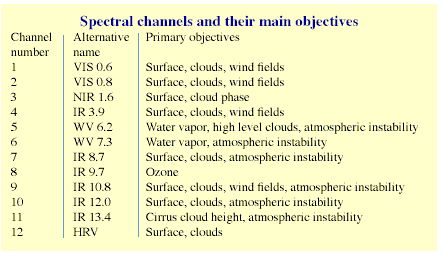
Fog detection from satellite images often presents a problem, especially at night. With no visible imagery available the forecaster must rely on infra-red images, but these may not be very helpful � the temperature of the ground surface may fall to a value close to that of the fog top, so they both appear as similar shades of grey. However MSG allows for improved fog detection based on the principle that the emissivity, or brightness, of fog at IR 3.9 is less than at IR 10.8. Simply displaying the difference between the radiation in these two channels can often reveal fog in areas that might otherwise appear as clear sky.
A notable feature of the MSG project is that several European meteorological services will host Satellite Application Facilities (SAFs), where data will be processed to produce information and products related to specific weather developments. Different SAFs will focus their attention on topics such as ocean and sea ice, ozone concentrations, and climate monitoring. Among the SAFs of particular interest to Met �ireann is that dealing with Support to Nowcasting and Very Short Range Forecasting, based at the headquarters of the Instituto Nacional de Meteorolog�a (INM) in Madrid. Output from this SAF will improve Met �ireann's overall forecasting capability and in particular help with the identification, tracking and monitoring of rain-bearing cloud systems.
Future developments
The deployment of the MSG satellites has already had a significant impact on Met �ireann's weather forecasting capability, and this will develop further as the MSG programme progresses. EUMETSAT also plans a series of polar-orbiting satellites (EPS - EUMETSAT Polar System), the first of which is due for launch in 2006. Polar orbiting satellites circle the Earth in an almost north-south orbit, passing close to both poles, at an altitude (approx. 800 km) which is much lower than the geostationary satellites. The geostationary and polar systems (MSG and EPS) will together provide complementary data of immense usefulness in operational weather forecasting.
Contact: Liam Campbell, Met �ireann, Glasnevin Hill, Dublin 9.
E-mail: [email protected]