| 2006 |

|
YEAR BOOK |
Ordnance Survey Ireland
|
The OSi National Network RTK Solution
|

Introduction
Ordnance Survey Ireland (OSi), the Irish national mapping agency, has a tradition of being at the leading edge in the use of new technology. Over the past decade OSi has been one of the world's largest civilian users of digital photogrammetry and continues to invest in new technology when it is proven to be cost effective in improving map production flowline efficiencies. This paper outlines OSi's recent implementation of a new GPS 'Network Real Time Kinematic (RTK)' solution for Ireland which has been developed in conjunction with Leica Geosystems.
OSi network service
The OSi national GPS (satellite positioning system) Network, which enables surveyors to determine their position in realtime around the country to accuracy better than six centimetres using instrumentation comprising of a geodetic GPS RTK receiver and GPRS / GSM mobile phone communications, has been implemented as an upgrade to an existing OSi active GPS network (network of permanently fixed recording GPS base stations) in Ireland. That existing network comprised ten active GPS stations, developed primarily to provide an hourly GPS RINEX data download service via the internet www.osi.ie allowing surveyors to post-process recorded GPS data in order to determine an accurate position.
The raw GPS signal received by most off-the-shelf GPS receivers would typically give a positional accuracy of only around the ten meter level due mainly to errors in the GPS data as a result of the signal passing through the ionosphere. However when using a realtime GPS network positioning service the errors are quantified in realtime by a central GPS computer application. The network processing application, based in OSi Head Office in the Phoenix Park in Dublin, constantly receives a stream of raw GPS data from each of the thirteen base stations around the country via DSL broadband communications, processes the realtime information and sends the required realtime corrections to the surveyors GPS receiver via GPRS or GSM mobile communications, thus enabling realtime GPS positioning accuracies better than six centimetres.
Solution overview
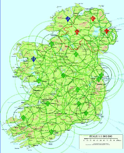
The new Network RTK solution currently comprises thirteen OSi active GPS reference stations as shown in Figure 1. As this realtime GPS positioning service was based initially on GSM communications, the current reference station locations were chosen in order to provide sufficient coverage in areas around the country where there was also good GSM coverage. OSi made the decision not to establish additional GPS reference stations on the South West coast of Ireland initially, but to wait until a time when GSM coverage had also improved in this area, thus enabling the realtime positioning service to be accessed.
System Hardware & Software
The OSi realtime positioning service is based on the Leica Geosystems 'Spider Net' GPS network processing software application and Leica Geosystems hardware. Each of the thirteen active GPS reference stations used in the solution consists of the same hardware configuration:
-
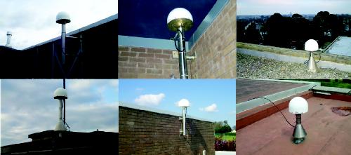
Leica Geosystems Choke ring antenna with radome antenna (as seen in figure 2)
-
Wall mounted security box containing: Leica Geosystems CR500 dual frequency geodetic receiver, UPS x2 (Uninterrupted Power Supply) & Fan, and DSL broadband communications links
-
Lightning arrestor
Geodetic Reference Framework
During 2002 a GPS observation campaign was carried out to coordinate the centres of the GPS antennae to EUREF Zero Class B specification (better than two centimetres in X, Y, Z) and to ensure consistency with the pre-existing Class B specification stations in Ireland. The observation campaign was designed and computed under contract by the IESSG at the University of Nottingham and provided a high level of confidence in the computed coordinates of the stations.
System Access
Up to this point external users have had access to the OSi realtime GPS positioning service free of service charge as part of an OSi beta testing programme. With thirty five OSi field surveyors having used the system for nearly a year, the network performance and stability is at a level of confidence for OSi to finish its beta testing and initiate the roll out of the service to the survey community as a 'pay-per-use' service. It is anticipated that this service will be made available early in 2007.
Existing RINEX service
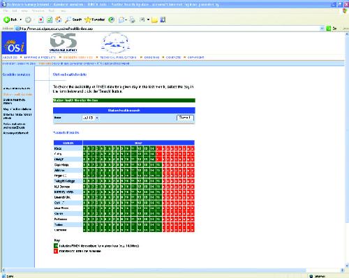
In parallel with the new realtime GPS positioning service, the existing GPS hourly RINEX service will continue to be provided over the internet www.osi.ie (see Figure 3) for those users wishing to avail of positioning by means of GPS post-processing. This RINEX service for Ireland currently consists of downloadable hourly five-second RINEX files from an archive period of three months for the thirteen OSi active reference stations and for the three Ordnance Survey of Northern Ireland active reference stations.
Important lessons learnt
Suitable Site Selection
During the implementation of the initial active GPS network important time was spent on the identification of suitable sites for the GPS antennae and receivers. Aside from the GPS requirement for open skies and minimum local obstacle interference, the main factors for site selection were security, electricity supply, existing telephone lines, and ease of access for on-going maintenance of the equipment. Typically the best sites enable the GPS cabinet (containing receiver, modem, UPS, and fan) to be installed within a lift-shaft housing near the roof, providing a short distance between the receiver and the antenna.
Network stability comes from stable communications
In the roll out and testing of the realtime network solution it was found that the stability of the positioning service was related to communications infrastructure and not the GPS equipment. It is very important to have a reliable communications infrastructure with built in redundancy in the event of system problems.
Future developments
A further development of the solution will involve the inclusion of the three Ordnance Survey of Northern Ireland active GPS stations in the RTK network, thereby increasing the coverage of the realtime positioning service to cover Northern Ireland and the North West of the Republic of Ireland. This will be achieved by in installation of a broadband communications link between the Network RTK GPS server in OSi Headquarters in Dublin and the Ordnance Survey of Northern Ireland GPS server in Belfast. One-second data will be streamed from the three stations to the GPS server in Dublin and the required GPS corrections will be sent back to the GPS server in Belfast where they can be accessed by users in Northern Ireland.
Contact: Contact: Colin Bray.
Senior Operations Manager,
Data Strategy & Development,
Ordnance Survey Ireland
Phoenix Park, Dublin 8. IRELAND
Tel. +353 1 802 5300 Fax +353 1 820 4156
E-mail: [email protected] Web: www.osi.ie