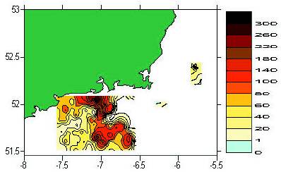
 Figure 1. Spatial variability in abundance of scallop (numbers
per 0.5 hour fishing effort) off the south east coast.
Shellfish such as scallops, mussels and clams are sedentary
animals that live in direct contact with the seabed (benthic
species). Their limited mobility means that their growth,
reproduction and survival depend on local environmental conditions.
These species have a complex lifecycle. Although benthic
as juvenile and adult, they produce pelagic larvae (i.e. in middle
depths and surface waters) which are dispersed by ocean currents.
Connectivity between patches of adults is therefore achieved
through dispersal and settlement of the larvae. The degree to
which these patches, which may be isolated from each other, are
interconnected has a major effect on how resilient they are to
fishing. They function as metapopulations (a series of inter-connected
local populations) with some risk of local extinction if
larvae do not recruit into such areas on a regular basis. Patches
may act primarily as sources or sinks for pelagic larvae. Areas that
supply larvae to the general population (sources) are of high
priority for conservation, as the risk of extinction in areas that
serve as sinks is greater if source areas are not conserved. Areas
that function as sinks, however, can be exploited heavily, as
the risk to general population recruitment failure is lower.
Management of these exploited species needs to consider how the
physical environment in any particular fishery affects the population�s
resilience to fishing.
Figure 1. Spatial variability in abundance of scallop (numbers
per 0.5 hour fishing effort) off the south east coast.
Shellfish such as scallops, mussels and clams are sedentary
animals that live in direct contact with the seabed (benthic
species). Their limited mobility means that their growth,
reproduction and survival depend on local environmental conditions.
These species have a complex lifecycle. Although benthic
as juvenile and adult, they produce pelagic larvae (i.e. in middle
depths and surface waters) which are dispersed by ocean currents.
Connectivity between patches of adults is therefore achieved
through dispersal and settlement of the larvae. The degree to
which these patches, which may be isolated from each other, are
interconnected has a major effect on how resilient they are to
fishing. They function as metapopulations (a series of inter-connected
local populations) with some risk of local extinction if
larvae do not recruit into such areas on a regular basis. Patches
may act primarily as sources or sinks for pelagic larvae. Areas that
supply larvae to the general population (sources) are of high
priority for conservation, as the risk of extinction in areas that
serve as sinks is greater if source areas are not conserved. Areas
that function as sinks, however, can be exploited heavily, as
the risk to general population recruitment failure is lower.
Management of these exploited species needs to consider how the
physical environment in any particular fishery affects the population�s
resilience to fishing.
In the south east coast of Ireland, a new research project involving
a multidisciplinary team of scientists is investigating the
dynamics of exploited scallop fisheries and how the physical
environment of the seabed and coastal currents may affect these
dynamics. This study, funded with EU assistance under the National
Development Plan, investigates four fundamental processes:
-
The spatial variability in the biology of scallop, and how this
variability may be affected by local environmental conditions
(BIM)
-
Mapping of the seabed using MULTIBEAM acoustics, and
relating scallop abundance and biology to the acoustic
signature or derived seabed type (Gerry Sutton, Coastal
Resources Centre, UCC)
-
Identifying the way in which hydrodynamics (water movement)
controls the dispersal and settlement of scallop larvae
and therefore the connectivity between different beds of scallop
in the area (Michael Hartnett, Marcon Computations Ltd,
Galway)
-
The relationship between scallop abundance and age structure
and the spatial distribution of fishing effort (BIM and the South
East Shellfish Association).
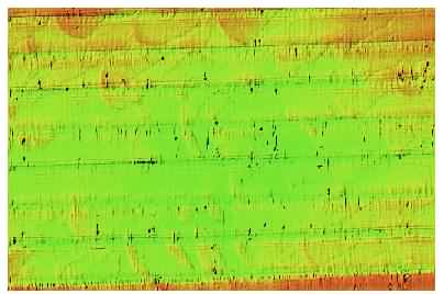 Figure 2. Acoustically derived image of the seabed in an area off
south Wexford. Arcuate (i.e. bow shaped) dunes which range
from 200�300m on the long axis by 50�100m in width are
arranged in long lineaments or trains with a distinct nw/se
alignment in accordance with the prevailing tidal current
directions. They are of low relief (0.5m) and probably composed
of medium grade sands over coarser gravel lag deposits.
The integration of physical and biological datasets within a
Geographic Information System (GIS) will allow the project
participants to develop a spatially explicit management model for
this fishery. Spatial variability in abundance of scallop (Figure 1)
and in the seabed environment (Figure 2) is clearly evident and
indicates the need to incorporate spatial effects in management.
Hydrodynamic control of larval input into these populations
probably controls the observed spatial pattern of abundance on the
seabed, although fishing operations will also have an effect.
Spatial analysis of these layers of information can be used to
identify relationships between biology, hydrodynamics and
seabed topography. These relationships are important in managing
the fishery through controlling the level of fishing and/or introduction
of different technical conservation measures that are
matched to local biological characteristics, and the taking into
account of the relative importance of different areas as sources
(rather than sinks) for larvae. In addition, accurate distribution
maps can reduce fishing costs and fishing effort as the fleet can
target areas of high abundance.
Figure 2. Acoustically derived image of the seabed in an area off
south Wexford. Arcuate (i.e. bow shaped) dunes which range
from 200�300m on the long axis by 50�100m in width are
arranged in long lineaments or trains with a distinct nw/se
alignment in accordance with the prevailing tidal current
directions. They are of low relief (0.5m) and probably composed
of medium grade sands over coarser gravel lag deposits.
The integration of physical and biological datasets within a
Geographic Information System (GIS) will allow the project
participants to develop a spatially explicit management model for
this fishery. Spatial variability in abundance of scallop (Figure 1)
and in the seabed environment (Figure 2) is clearly evident and
indicates the need to incorporate spatial effects in management.
Hydrodynamic control of larval input into these populations
probably controls the observed spatial pattern of abundance on the
seabed, although fishing operations will also have an effect.
Spatial analysis of these layers of information can be used to
identify relationships between biology, hydrodynamics and
seabed topography. These relationships are important in managing
the fishery through controlling the level of fishing and/or introduction
of different technical conservation measures that are
matched to local biological characteristics, and the taking into
account of the relative importance of different areas as sources
(rather than sinks) for larvae. In addition, accurate distribution
maps can reduce fishing costs and fishing effort as the fleet can
target areas of high abundance.
There are additional benefits to this spatially explicit approach
to management. Areas off this coast have been nominated as
Special Areas of Conservation (SAC) under the EU Habitats
Directive. In these areas, the objective is to conserve biodiversity
by limiting the level of human activity. Spatial analysis of dispersal
and recruitment from the SAC can be used to demonstrate the
benefits to exploited fish populations in the area as a whole, especially
if these SAC areas act as sources rather than sinks for larval
populations. The twin objectives of conservation and sustainable
fisheries can therefore be achieved with this spatially explicit
integrated approach to management of the marine environment.
Contact: Oliver Tully, Fisheries Development Division, BIM,
Crofton Rd, DunLaoghaire, Co. Dublin; E-mail:
[email protected]
|