For such a small nation, Ireland has a remarkable track record of producing some of the greatest minds in human history. From a womanising molecular biologist to the man who developed radiotherapy as a treatment for cancer, the Emerald Isle has vastly contributed to scientific discovery and invention throughout the ages. We’re going to introduce you to seven of the most well-known Irish scientists with a little explanation about their significant contributions.
1] John Desmond Bernal.
Let’s kick things off with one of the most colourful scientists ever to have lived. He is renowned for laying the foundations of the modern study of molecular biology by pioneering the use of x-ray crystallography. He studied and then lectured at Cambridge, but this is only scratching the surface of his life. Known as a serial womaniser and Communist activist, he was a divisive character, to say the least. But he was well respected and trusted in his field and was later employed by the British Ministry of Defence, where he advised Sir Winston Churchill on the D-Day landings.
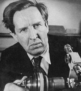
2] Ernest Walton.
Ernest Walton remains the only Nobel Prize winner in physics to come from Ireland. During his experiments at Cambridge University in the 1930s, Walton and his colleague John Cockcroft became the first men to split the atom. Their successful experiment initiated an era of particle-accelerator-based nuclear physics, and they went on to be awarded the 1951 Nobel Prize in physics as a result. Following his success at Cambridge, Walton returned to Ireland and enjoyed a successful career at Trinity College in Dublin, where he became an extremely popular lecturer and esteemed researcher.

3] Kathleen Lonsdale.
Dame Kathleen Lonsdale achieved remarkable things in science, as well as other aspects of her life. As a crystallographer, she was the first to prove that the benzene ring was flat through x-ray diffraction in 1929. Alongside her successful scientific career, she also became the first woman elected as a Fellow of the Royal Society and the first woman tenured professor at University College London. Her legacy is displayed at the Science Museum in London, where you can find many of her crystallographic models that formed much of her research and work.

.jpg)
4] John Joly.
After joining the Royal Dublin Society as a student in 1881, John Joly would go onto publish a number of papers detailing his vast array of experiments across a range of fields. But he is most famous for his discovery that radiotherapy could be used to treat cancer. Such a telling contribution was almost ahead of its time and undoubtedly went on to save the lives of millions. Some of his noteworthy publications included insights into the slipperiness of ice, as well as an estimate on the geological age of the earth, the latter of which he posited the world to be somewhere between 80 – 100 million years old, an extremely radical viewpoint at the time.
5] Frank Pantridge.
The impact of Frank Pantridge’s contribution to science is similar to that of John Joly. During his time as a British soldier, Pantridge was captured and served time as a prisoner of war in Japan. After being subjected to live as a slave labourer on the Burmese Railway, Pantridge became emaciated and contracted cardiac beriberi, a condition he suffered for the rest of his life. When he returned to his studies in England, his research interest was in electrocardiography. He was responsible for introducing the modern system of CPR for the initial treatment of cardiac arrest before creating a device that would become known as the portable defibrillator. He first installed a defibrillator into a Belfast ambulance in 1965, but it wasn’t until the 1990s that all front-line ambulances in the UK were required to be fitted with the devices.
6] George Johnstone Stoney.
The man who gave the scientific term ‘electron’ its name, it’s perhaps by this classification that this great scientist is best remembered. He described the electron as ‘the fundamental unit quantity of electricity’ and would go on to publish more than seventy-five research papers throughout his life. Interestingly, many of Stoney’s family members went onto achieve scientific acclaim for themselves. His daughter Florence Stoney OBE was a renowned radiologist, while another of his daughters, Edith, was widely considered to be the first female medical physicist. In spite of his prolific writings on other topics, Stoney is undoubtedly best remembered for his conceptualisation of the electron.

,Undated(DateGuessedEarly1890s).jpg)
7] Nicholas Callan.
Anyone with a nickname like the ‘Frankenstein of electricity’ is worthy of an introduction! Reverend Nicholas Callan was one of his time’s most celebrated inventors, and he successfully built huge battery systems at his laboratory at Maynooth University. He was responsible for the world’s largest battery pack when he combined 577 individual cells and 136 litres of acid and later went onto discover and utilise the induction coil. It’s thought that Callan would keenly experiment with his induction coil and is once thought to have knocked an archbishop of Dublin unconscious after one such experiment! His work is celebrated at his place of work in Maynooth, where his instruments are displayed at the College’s science museum.

Closing thoughts.
For a considerably small island, Ireland has produced its fair share of scientific talent over the years. The seven ingenious minds that we’ve introduced above have all made telling contributions to their fields, and their lasting contributions have revolutionised the way in which we understand the world and its possibilities. It’s also clear that even though they were renowned scientists, many of them also lived rich and exciting lives, living out their passions and making valuable contributions in many other walks of life.
Site supported by: